Adventure Flying Guide – Conducting the Adventure
Weather and NOTAM information
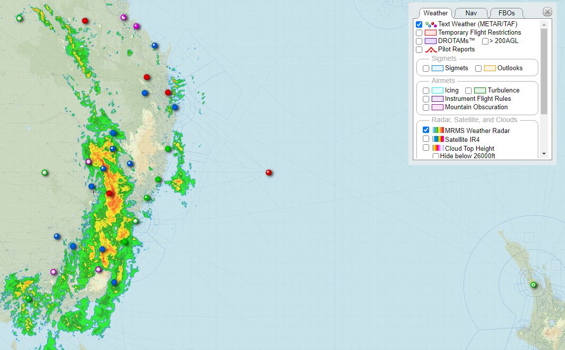
Weather
The availability of weather information varies greatly from region to region.
There are a couple of services which I use for overall, worldwide weather availability. The first is simply skyvector.com, which provides easy access through their map to METARs, TAFs, and other weather announcements such as SIGMETs. The second is Windy.tv – this is available as both a web page and an app and provides excellent graphical representation of things such as cloud ceilings, visibility, wind strengths and directions, and many more.

More specific information can be received from the aviation weather services of the countries you’re flying through. If you’re obliged to use a handling agent, then their services generally include provision of weather information, and they’ll typically provide a briefing pack before the flight. Most international airports, and often other smaller ones internationally, will have a flight information office which can offer a weather briefing if you go and ask them.
In flight it’s possible to use a Garmin InReach to get updated weather information en route, particularly in terms of METARs and TAFs, using a service such as MorrWX. Using this service you can send a message requesting METARs and/or TAFS for a specific location using the ICAO airport code, and the weather information will be sent back to your InReach. The beauty of this is that it works anywhere in the world; I’ve used it in Arctic Canada, or over the middle of the Indian Ocean, when even radio contact has not been an option.
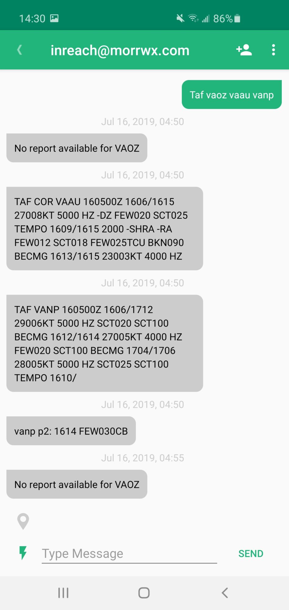

The InReach can also be a good communication link back to a friend or group of friends, who can be sitting behind a computer and looking at the latest weather data, then sending the information and recommendations back to you. My friends Joachim, Gavin and others have helped me out with this at various points!
NOTAMs
Getting hold of NOTAMs is not always easy. Trying to be in contact with ATC as much as possible is a good protection (although not foolproof) against any which you may have missed.
- Many EFBs have their own NOTAM briefing options, which are great within the areas they cover.
- For airport NOTAMs, the FAA NOTAM site is a good option. It covers airports world-wide.
- If using a handling agent, they will usually provide a NOTAM briefing for your flight. If they don’t, ask!
- International airports often have a flight information office, which can provide you with NOTAMs among other services.
Click here to return to the Adventure Flying Guide.
Flight plans
There are a couple of topics around flight plans that may be unfamiliar when flying abroad. How to fill them out, and how to file and activate them.
Filling out a flight plan
Every country that I have flown to so far has used the standard ICAO flight plan format, so the standard sections; aircraft type, speed, altitudes, etc should be familiar to you already. I won’t cover these again; if you’re in need of a reminder, a quick online search will suffice. However when flying internationally there are some additional sections that will need to be filled in, or quirks to filling in common sections, that you should be aware of.
- Departure/Destination: Some countries are quite stingy in handing out official airport identifiers. If your departure and/or destination airports do not have a 4-letter identifier, enter “ZZZZ” instead. Then, in section 18 (Other Information), enter the departure and/or destination airport using DEP/ and DEST/. For aerodromes not listed in the relevant Aeronautical Information Publication, indicate location as follows: with 4 figures describing latitude in degrees and tens and units of minutes followed by “N” (North) or “S” (South), followed by 5 figures describing longitude in degrees and tens and units of minutes, followed by “E” (East) or “W” (West). Make up the correct number of figures, where necessary, by insertion of zeros, e.g. 4620N07805W (11 characters).
- Level: Make sure you check the AIP and file an appropriate altitude for your direction of flight. Most countries have their own version of the semi-circular or quadrantal rules for appropriate VFR and IFR cruising altitudes; but they are not all the same! New Zealand, for example, splits their semi-circular rule into northern/southern directions of flight rather than the more typical eastern/western.
- Route: Choosing a route can be tricky. Make sure you’re very familiar with IFR charts and the restrictions on airways (allowable altitudes and directions, for example). A good rule of thumb is to use IFR routes to select your route even if VFR, unless you’re in a country where you know VFR is common. Europe is particularly awkward for choosing an IFR route; allowable routes change on a daily basis. The only sensible way to choose an IFR route in Europe is to use a service such as Autorouter to identify and validate a route for you.
- Other Information: EET. If crossing an FIR boundary, include the elapsed time at which you expect to cross each boundary using EET/. For example, EET/NZAA0430 would mean you expect to enter the NZAA Flight Information Region 4 hours and 30 minutes after departure.
- Other Information: OPR. Enter the Operator of the aircraft here; usually just your name. For example OPR/SMITH.
- Other Information: RMK. This is for any other relevant information; the most common would be your permit number. For example, RMK/THAI PERMIT ATD 5695/07/2019. You can put additional RMK/ sections as required.
- Supplementary Information. This includes information such as your survival equipment; cross out the items that you don’t have, and leave the items carried unmarked. Section N, labelled “Remarks” is for survival equipment related remarks only (such as a link to your satellite tracker); general remarks should go in section 18, “Other Information”, with the RMK/ tag.
- Pilot in Command. Include your phone number with country code.
Plenty of extra information on filling out the ICAO form can be found at the FAA flight plan link.
Filing a flight plan
There are as many different ways of filing flight plan as there are countries, it seems; possibly even more, as I’ve encountered differences even between airports inside the same country!
- If you’re using an EFB such as SkyDemon, Foreflight or others, they will often allow you to file a flight plan from directly within the app.
- In Europe, an excellent website called Autorouter offers a free service for generating valid flight plan routes, and filing them.
- AIP section ENR 1.10 and 1.11 offer information about how to file flight plans, and the AIP sections for specific aerodromes will sometimes give information as well. One airport in Malaysia just listed their yahoo.com email address in their AIP entry as the contact for flight plan submission!
- On arrival at an airport, ask about how to file your departure flight plan before you leave and head to your accommodation. Ask at the airport info desk, and they’ll often then direct you to the flight information office or similar.
- Phone the tower, if you can find a number for them.
I once arrived at an airport in Cameroon to depart; it was technically closed that day, but we’d been told that the key staff would come in for us. The lady who took the fees showed up (of course) but the man who did the flight plans was nowhere to be seen. “No problem”, said the lady, “fill in the form and I’ll deal with it”. I completed it and handed it to her. She placed it in the top drawer of the flight planning desk; “I will give it to him next week and he will take care of it”. Off we flew anyway, and nobody gave us any hassle!
Click here to return to the Adventure Flying Guide.
Diversions
Diversion is a fact of life for any pilot, and an important safety tool. When on an adventurous flight in a remote or unfamiliar region, a diversion is not necessarily as simple as when on your home turf. There are a lot of extra options that need to be considered. Think about all of these issues in advance of any flight, and try to determine where you’d divert to at various points along the route, so you don’t have to be trying to think everything through in the cockpit at the same time as dealing with whatever has caused your diversion.
Permits
A permit will generally be valid for your designated airports only. Different countries offer differing levels of flexibility around landing at an airport which is not listed on your permit; most are not going to cause you too much trouble in a situation where the diversion is essential for safety, although it’s possible you may have to argue your case. Never be afraid to put the safety of the flight first, it’s better to be dealing with bureaucratic headaches on the ground than to end up in an accident.
If possible, try and include some designated alternate airports on your permit. Some countries will allow it, some will not, but it can make life easier if you need to land at one of them. If you have someone on the ground back home assisting you with things, such as a permit agent, then contact them in-flight if at all possible at the earliest opportunity once you’ve made a decision to divert; they might be able to start contacting the destination and lining things up for you to ease your arrival.
Some countries can be very unforgiving, especially if you don’t have a permit for that country at all. For example, when crossing the Indian Ocean there are airports in Indonesia which can be the closest alternate at various points, even if your route does not take you into Indonesian airspace and hence you have no overflight permit. However, GA pilots have been known to have been met with a harsh welcome when diverting to Indonesia; one was met at the aircraft by soldiers with weapons drawn, and given a very hard time for a while.
Others can be welcoming, but be prepared; a diversion to an unplanned airport is unlikely to result in a quick turnaround. When we were denied entry into Guinea Bissau due to the tower controller transposing permit numbers, we diverted to an airport in Senegal. They were helpful, and White Rose Aviation quickly cleared up the permit trouble; but customs and immigration in Senegal decided this was a great opportunity for a thorough inspection and we spent two hours emptying and repacking the aircraft while they carefully examined everything on board.
Fuel availability
AVGAS can be very scarce. When considering diversion options up front, consider whether your preferred fuel is available and, if not, whether you’d still have enough range to head on to your planned destination after a diversion to an airport which could very well be a fair distance off your original route.
Security
There are some countries where you might be willing to overfly, but would prefer not to land. If your route takes you over one of these (examples on my travels have been Mauritania, the Niger Delta, and western Sudan), then consider in advance what you’d need to do to stay safe if forced to divert to an airport in one of these areas.
Insurance
Most insurance will cover you for an unplanned, safety-critical diversion even if the territory you land in is excluded from your policy. Make sure of this in advance before planning any routes that overfly excluded areas, though!
Schedule
There’s a good chance that a diversion will eat up an entire day. Make sure you have a bit of float in your planned schedule for such an event! Overflight and landing permits usually have a window of validity of a few days, to cater for this.
Click here to return to the Adventure Flying Guide.
Photography
When travelling with photography in mind, or even worse videography, they can quickly overwhelm the actual joy of the trip itself and turn into the primary purpose. I do my best to avoid this, and therefore I do not go overboard with photographic equipment. The only devices that I carry are a Samsung Galaxy S10 smartphone, and an Olympus point-and-shoot rugged waterproof and shockproof camera.
The Samsung Galaxy S10 is my main device, and because it’s always on my person, I can be ready to snap a picture of anything that catches my eye. The Olympus is really just there for situations the smartphone might not survive, such as water-sports, torrential rain, and so on!
I have not found any need to do any post-processing of the photos taken with these devices, other than cropping and resizing to suit the website.

Whatever digital photography solution you select, I strongly advise having a way to back-up your photos to online storage as often as possible. It would be horrible to lose or break your device and lose your photographic record of the trip. A phone will generally offer the option to automatically upload your pictures to a private storage area online; I use the Dropbox app to automatically upload mine.
Important: some countries do not permit aerial photography, or photography of sensitive sites which can include airports. If in doubt when air-side, ask permission before taking photographs! If you have externally mounted cameras such as GoPros, it’s best to leave these un-mounted and tucked away somewhere when arriving or departing from countries which have these rules (such as Egypt) or you could find yourself in a lot of difficulty.
Click here to return to the Adventure Flying Guide.
Communications and altimetry
Radio frequency spacing
Radio frequencies in Europe are allocated with an 8.33kHz spacing, rather than the 25kHz spacing seen in the rest of the world. It is mandatory to carry 8.33 capable equipment for flight in European airspace. If you have a GPS/Nav/Comm such as Garmin’s GNS 430/530 or GTN 650/750, or Avidyne’s IFD 44/540/550, you can find the option to enable 8.33kHz spacing in the settings menu.
If you don’t enable this before entering European airspace, you are likely to find you can’t set assigned radio frequencies, and everybody will get upset.
Add photo: 8.33 frequency example.
Passing estimates
In much of the world outside of North America, Europe, and a few others, air traffic control is very procedural, and relies quite heavily on position reporting and provision of “estimates” (estimated times of arrival) for way points along your route. Often your wheels will barely have left the ground before the controller is asking you for your estimates for arrival times at every one of your flight-planned way points; so, have these ready in advance! It doesn’t matter if they aren’t exact; you can always update ATC later with new estimates once you’re in the cruise.
They’ll expect you to pass your estimates in UTC/Zulu time. If you can set your GPS up to show ETA at each way point along your route, in UTC, then this makes things much easier; once you’re in the cruise, the estimates will usually be accurate enough.
Add photo: IFD540 with estimates for each waypoint displayed.
Comms in remote areas
Most of your communication will be through the usual method of VHF radio. However, in more remote areas this won’t work; you usually won’t get more than 100nm of range out of your VHF set. ATC will usually want you to report in at various points, however; usually an “Ops Normal” call every 30 minutes or hour, or a report when crossing various flight-planned waypoints.
There are a couple of methods that I’ve used for communication when outside of VHF range. The “official” system is to use an HF radio. This requires having a radio, tuner, and very long antenna installed in the aircraft but can be done relatively simply using a portable set such as an Icom 7000. The vast majority of flights outside of VHF range can be accomplished using other communication methods however.
Add photo: HF setup in N9953H
The most common, and simplest, is to get a message relayed by other traffic; most usually airliner traffic up high in the flight levels. You can call blind on 121.5 requesting a message relay and usually get an answer. A lot of airliners monitor 123.45 as well, so that’s a good alternative to try. If there’s nobody around, keep trying every few minutes. At the speed which jet airliners fly, they can come in and out of your radio range fairly quickly.
If you are equipped with ADS-B in, you can refine this technique by watching to see which airliners are nearby, and then call them up by name. This is a good way of getting a response! When I’ve seen airliners overtaking me on a similar track, I’ve even had success with asking them to tilt their radar down and tell me how the weather looks along the route ahead.
Add photo: ADS-B page with targets (airliners)
An alternative is to ask ATC for a satellite phone number before you lose contact; you can then call in your position reports to them using this number. Most of the time ATC will accept this, even if the regulations technically say HF radio is the only acceptable communication method. Be aware however that they could technically refuse you and ask you to turn around if you don’t meet the regulations, and some controllers (such as the US) will not accept a satellite phone in place of HF!
A more elaborate work-around, if you don’t have a satellite phone but do have a messenger such as a Garmin InReach, is to use the InReach to send the phone number to a supporting individual, who then phones in your position reports to ATC for you whenever you send them a message.
Transponder setting
For the majority of flights you are likely to be in touch with Air Traffic Control and on an assigned transponder code. However, if you find yourself needing to set the standard VFR code at any point, note that it is different outside of the US and Canada. The US/Canada use 1200, whereas most of the rest of the world uses 7000. Check the AIP of each country for specifics as the use of 7000 is not quite universal.
Altimetry
If you are used to flying in the US/Canada, you’ll be used to setting your altimeter using inches of mercury (29.92 standard setting). The rest of the world uses millibars, with 1013 being the standard setting. When flying from one region into the other, check that you can enter the required altimeter setting standard into your instruments. If not, be sure to carry a conversion table.
Add link to conversion table.
In the United Kingdom, it is common for air traffic control to give you the “QFE” setting when approaching or departing an airfield.
Complete section.
Click here to return to the Adventure Flying Guide.
Staying alert
Staying fully awake and alert on long flights, especially if you’ve set off very early in the morning, and even more so if you haven’t slept well the night before! I rarely sleep well the night before a big, challenging flight. On a long flight, setting off from a typical foreign international airport, you’ll need to arrive a couple of hours before departure. This makes for a very long day, if there’s 8, 10 or even more hours of flying ahead of you.
In the planning section we discussed scheduling your trip to try and ensure enough rest, but it doesn’t always work out that way; in Al Ain, Gavin and I found out late evening after a flight from Bahrain that instead of a few days rest and a 7 hour flight to Ahmadabad, we’d need to set off at 4am the next morning and fly for 11 hours all the way to Nagpur.
One thing that helps a lot on a lengthy flight is having another person to share the load, especially if they can help fly. In the example above, I was able to sleep for a while en-route because I had Gavin, a qualified pilot, to monitor the radios and the autopilot. Having another pilot is not always an option though, especially on extreme range flights where you can’t afford the weight.

Particularly when solo, do all you can to be rested in the days before the flight. Keep well fed and hydrated (although avoid any foods that might lead to an uncomfortable digestive situation in flight!) Ensure you have plenty of drinks; ideally water or electrolyte drinks and juices, and also a variety of snacks to keep your energy up. Remaining hydrated will of course lead to an unavoidable biological function, that can be taken care of through use of a “Travel John” or similar; these disposable travel urinals contain a powder that turns any liquid to a gel, and eliminate any concerns about drinking!
If at all possible, find a way to connect your phone or tablet to the aircraft intercom or your headset, and keep it loaded with music, audio books, and podcasts. On long ocean crossings there’ll be very little radio traffic, and this will help keep you awake and engaged.
A headset with Active Noise Reduction (ANR) helps greatly with reducing fatigue from cockpit noise, allowing you to enjoy media, and preventing you from missing radio calls.
Click here to return to the Adventure Flying Guide.
Maintenance away from home
There are two main things to consider if you need to get maintenance carried out on your aircraft when traveling abroad. The first, and most important to me, is finding a mechanic who is knowledgeable and experienced in working on your aircraft type. The second is finding someone who can sign off the work. They don’t necessarily need to be the same person.
Whatever happens, in the event of any mechanical issue away from home, your first call should be to your mechanic back at base to discuss the issue and come up with a plan for dealing with it. Remember, he or she is the one who’ll be signing off your annuals in future so it’s important to make sure he’s satisfied with any work done in between inspections! The more knowledge you have about your aircraft’s mechanical systems the better, as this will allow you to more effectively discuss and diagnose issues with your mechanic remotely, as well as properly supervise any work that needs to be done.

Finding a local mechanic is usually just a case of asking around. If you’re in need of unplanned maintenance somewhere, beggars generally can’t be choosers. If you’re flying an N-reg aircraft there’s a good chance of finding an FAA qualified mechanic, as this maintenance regime is so wide-spread. If you can’t find someone who is qualified to work on your nationality of aircraft, you may need to just accept whoever is available, and liaise with your mechanic back home about the best way to manage the paperwork.
Before allowing any work to be done, make sure that you’ve agreed with your mechanic and the maintenance provider about how the paperwork will be handled. In the worst case you might find yourself having to entirely re-do the work once home, if the sign-offs are not done correctly. You are unlikely to have your airplane logbooks with you, so ask the maintenance provider to print out the logbook entry so you can stick it into the logs once home.

In extremis, you may need to bring in a mechanic from elsewhere, so be prepared mentally and financially to make that decision if it comes from it. Flying through Africa in 2013, we had to fly a mechanic from the Netherlands to Nairobi in order to carry out maintenance checks and repairs on the SMA-engined diesel C182 we were flying. There was nobody closer and available who was qualified to work on that rare engine.
Click here to return to the Adventure Flying Guide.